IU366. GDAŃSK LIGHTHOUSE

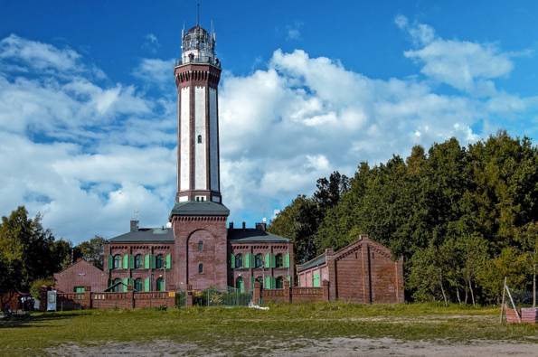
LOCATION One of the most beautiful lighthouses of the Baltic Sea (geographical position 54°24’28”N, 18°39’50”E) this 90-feet-tall structure built in 1893 is the twin of the Cleveland, Ohio, Main Lighthouse (today no longer standing). photo source: ATTRACTIONS Situated at the entrance of the harbour of Gdańsk, the Nowy Port Lighthouse combined three distinct functions: that […]

Continue Reading

IU302. MANORS IN KRETINGA AND PLUNGĖ

LOCATION Kretinga and Plungė towns are connected by highway A11 and have good railway and bus connection with other cities in Lithuania. Plungė Manor park, photo  source: wikimedia commons. SCENIC CHARACTER Kretinga is one of the oldest settlements in Lithuania, also called the Franciscan capital due to 5 established monasteries here. Kretinga district is famous not […]

Continue Reading

IU263. THE TOWN HALL IN STARGARD

LOCATION The Town Hall is located at the Old Town Square, between the streets of Kramarska and Kazimierza Wielkiego. 53° 20′ 14”, 15° 2′ 47” photo source: wikimedia commons. ATTRACTIONS  The Town Hall – the symbol of Stargard often shown in photos and postcards from the city. It is a Gothic building built in 1250 and […]

Continue Reading

IU262. THE ORDER OF SAINT JOHN CASTLE IN SWOBNICA

LOCATION Swobnica is a small village in the Banie commune. To get to Swobnica, take route E65, then exit the voivodship road no. 122. After Banie, drive 4 km and exit DW 122 to the left. The castle is slightly behind the village. Ok. 900 meters behind it, we should turn into a forest road, left. […]

Continue Reading

IU260. CZCIBOR MOUNTAIN

LOCATION Czcibor Mountain located on the route no. 124, running along the Oder, 4 km after Cedynia and less than a kilometer in front of Osinów Dolny. It lies within the administrative borders of the Cedynia commune, in the Gryfino poviat. 52° 51′ 18”, 14° 9′ 26” photo source: wikimedia commons. ATTRACTIONS  Czcibor Mountain is […]

Continue Reading

IU258. PALACE OF MILLER IN KOSZALIN

LOCATION Located in the Koszalin city center, north of the town hall, at the intersection of Młyńska and Podgrodzie Streets. Next to the building there is a car park for approx. 20 passenger cars. 54°11’35” N, 16°10’55” W photo source: wikimedia commons. ATTRACTIONS  Today’s Palace of Miller in Koszalin dates back to the 19th century. […]

Continue Reading

IU257. CATHEDRAL IN KOSZALIN

LOCATION Cathedral The Immaculate Conception of the BVM is located in Koszalin, at ul. Bolesław Chrobry. The facility is located approx. 600 m from the railway station. 54°11’22.1″N 16°10’49.1″E photo source: wikimedia commons. ATTRACTIONS  The Cathedral of the Immaculate Conception in Koszalin – formerly the parish church in Koszalin. It is the most important and […]

Continue Reading

IU256. CASTLE IN ŚWIDWIN

LOCATION The castle in Świdwin is located in the western part of the city. From the station you should head towards the center, go under the Stone Gate, then behind the town hall emerges a substantial building of the castle. 53°46’21.1″N 15°46’07.2″E photo source: wikimedia commons. ATTRACTIONS  The first castle in Świdwin was created from […]

Continue Reading

IU255. LIGHTHOUSE IN NIECHORZE

LOCATION Lighthouse located in the village of Niechorze (Rewal commune, gryficki poviat, West Pomeranian Voivodeship), on a high cliff shore. The lighthouse is located between the Lighthouse Kikut (about 30 km to the west) and the Lighthouse Kołobrzeg (about 34 km to the east). 54°05’41.3″N 15°03’49.8″E photo source: wikimedia commons. ATRACTION DESCRIPTION The lighthouse in […]

Continue Reading

IU254. CASTLE IN KRĄG

LOCATION   Located between Koszalin and Słupsk 54°12’59.2″N 16°42’09.9″E photo source; wikimedia commons. ATTRACTIONS  A historic castle located in Krąg directly at the Castle Lake The first mentions of the stronghold come from 1495. Knight Adam Podewils received for his merits as a gift from the prince Bogusław X a tower. The tower was pulled […]

Continue Reading